


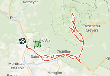
Archiane

gerardbedoret
User

Length
48 km

Max alt
1134 m

Uphill gradient
1319 m
Km-Effort
66 km

Min alt
438 m

Downhill gradient
1355 m
Boucle
No
Creation date :
2024-10-19 10:27:19.0
Updated on :
2024-10-19 19:26:09.665
6h00
Difficulty : Very difficult

FREE GPS app for hiking
 SityTrail
IGN / Geographical institutes
SityTrail Plus
The world is yours!
About
Trail Mountain bike of 48 km to be discovered at Auvergne-Rhône-Alpes, Drôme, Solaure en Diois. This trail is proposed by gerardbedoret.
Positioning
Country:
France
Region :
Auvergne-Rhône-Alpes
Department/Province :
Drôme
Municipality :
Solaure en Diois
Location:
Unknown
Start:(Dec)
Start:(UTM)
691446 ; 4952420 (31T) N.
Comments